STOKE SUNDAY HISTORY SPOT
Investigating the Past, to Understand the Present, to Plan for the Future
Click HERE for Main History Site
Listed Buildings
How did you get on with identifying the buildings? Here are some descriptions, but please remember that most of these sites are private property, and please respect people's privacy. Also, this information does not come from primary research, so please let me know of any inaccuracies and any other information you may have. If you want to know more about any of the buildings, please follow the link HERE
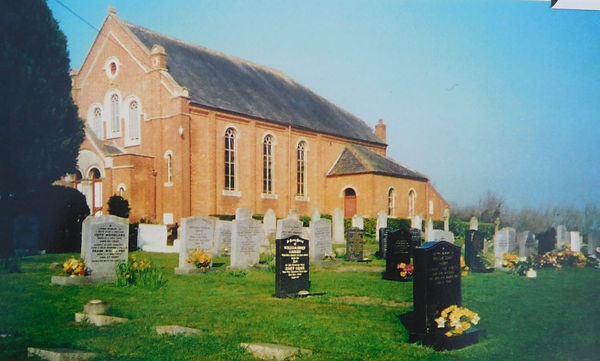
The Baptist church and the stables are both listed. We can all see the church itself from the road, but the stables are a red brick, double Roman tiled single storey 3-bay shelter shed with a tackroom adjoining on the right. The stables were for the horses of the parishioners attending the service. It is doubtful whether an carriages would have made it up the steep slope.
Although the pews have been removed from the body of the church, the canted continous gallery with cast iron enriched railings, carried on cast iron columns, remains.
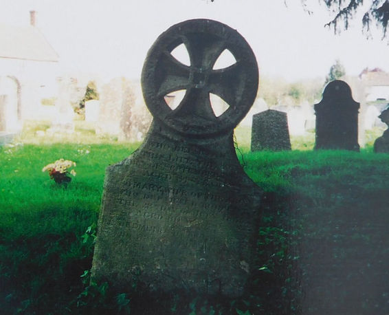
The Barrington Monument in the churchyard, about 10 m south-east of the south porch. The suggested date is 1782 but it could be earlier. Made of Ham stone, the upper section is carved with angels' heads flanking an hour glass with a skull. It is inscribed to Elizabeth Barrington and Edward Barrington. It is the only surviving early headstone in the churchyard.

This is an unidentified monument in the churchyard, about 15 m south of chancel. It is a chest tomb, possibly 16th Century. With a Ham stone top, it bears a coat of arms, said to be those of the Montague family who owned Slough Farm in the Middle Ages.
Churley Farmhouse. The house is possibly 16th Century, with alterations and editions in the following centuries. Set with the gable end onto road facing east, it is a possible open hall house with a cross passage. One day it may get the survey it deserves.

Crossway Farmhouse. This is possivbly a 17th Century, altered and enlarged later. C18-early C19, and again early C20. Originally it would probably have been a 3-cell and cross passage building.
Curload Farmhouse. Again probably 17th Century, extended at the east end in later centuries. With some thatching, there are also some interesting triple roman tiles on part of the roof. The majority of clay tiles in the village are double romans, but these were designed for faster laying and better waterproofing at a time when bridgwater’s competition was emerging from other parts of the country.

Dyke's Farmhouse, now divided into 2 dwellings, described as late medieval, with a west wing addition dated 1638. With its Ham stone dressings and thatched roofs, it is thought to have been an open hall house with cellar below, entered originally from the hall.

Frog Lane Farmhouse. Dated 1744, but possibly earlier, and altered mid to late 19th Century.

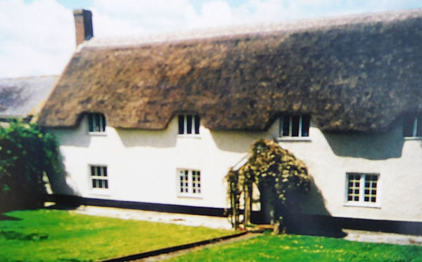
Woodhill Farmhouse. The farmhouse and the outbuilding are probably late 17the Century, altered mid 20th Century. It is built in red brick with a lias plinth, with double Roman tiles. The plan appears to be 3-cell and cross passage with a stair turret set in outshot. It has a long frontage of 4 dormers rising through the eaves. It is unusual for the kitchen to occupy the position of the inner room, and the possibility that the stair rises behind the through passage rather than out of the hall would be another uncommon arrangement.

Jessamine House and Long Cottage. A late medieval, altered and extended when the roof was raised C20. It wass an L-plan open hall house with cross passage and a lean-to west gable end. The proximity of the dwelling to the Church of St Gregory and its antiquity suggests that it may have been the Priest's house.

Lane End Farmhouse. It appears to have originally been constructed as a stone-built house dating from the C18 or earlier and was substantially rebuilt in brick in the early C19. Associated with the house are a number of agricultural buildings which were added at various dates between the C18 and early C20. The first edition Ordnance Survey map of 1889 depicts the farmhouse as a U-shaped building situated alongside the road between North Curry and Stoke St Gregory, and its footprint has remained little changed up to the present day except for the loss of a range orientated SW-NE at the NE corner. The house is a good example of a vernacular dwelling, and the evidence of its evolution adds to its claims to special interest.

Poplar Farmhouse. Probably late 16th - early 17th Century, and restored in the late 20th Century. It is an L-plan, 2-cell and cross passage house.

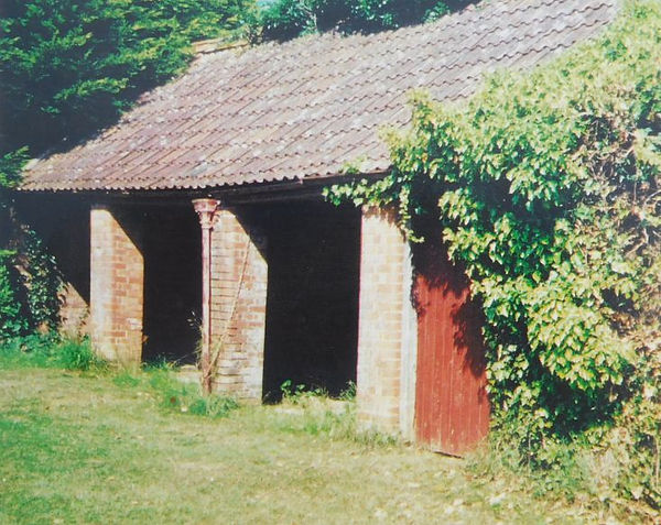
Barn near Slough Farmhouse. This is probably 17th Century, said to be timber framed over a low stone wall. It has a full height hipped porch with weather-boarded returns, 2 pairs of double doors, with mounting block adjoining.

Gateway to Slough Court. The gateway and walls are probably 16th Century, altered in the 19th, and repaired mid 20th Century. It is a buttressed archway with low walls along the site of an earlier drawbridge over a moat, most still extant on south side. It is possible that some of the earlier structure of the bridge over the moat survives beneath.

Church of St Gregory. Yes, this is the parish church. SParish church. Dating from the 15th Century, the church was added to, then restored in Victorial times, when the tower was strengthened, and the west gallery was removed. For more details click HERE

Stocks and bench in Churchyard. To be found about 14 m south of the church porch, built originally 17th or 18th Century, they have been much restored. They are made of wood and iron on a standard plan with 6 circular openings, in all about 1.75 m long, with the bench in situ. It seems that it is rare to find a bench surviving with the stocks.

Sturt's Farmhouse. A farmhouse with wall linking outbuilding at rear. Early-mid 19th Century. There is a blue lias outbuilding adjoining.

The Laurels. This is shown on OS map as Laurel Villa, the house being built around 1830.
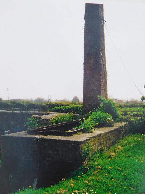
Withy boiler at Lovell's Farm. The boiler is dated 1906, with the chimney set square on at east end. The stoke hole is flanked by 2 square iron doors, the left hand one with name of Gibley and Son. The chimney has a painted brick inscribed JE 1906 (Builder, Joseph England, lived in a cottage, now demolished, where the village hall road entrance starts).

Woodhill Farmhouse. The farmhouse and the outbuilding are probably late 17the Century, altered mid 20th Century. It is built in red brick with a lias plinth, with double Roman tiles. The plan appears to be 3-cell and cross passage with a stair turret set in outshot. It has a long frontage of 4 dormers rising through the eaves. It is unusual for the kitchen to occupy the position of the inner room, and the possibility that the stair rises behind the through passage rather than out of the hall would be another uncommon arrangement.
