STOKE SUNDAY HISTORY SPOT
Investigating the Past, to Understand the Present, to Plan for the Future
Click HERE for Main History Site
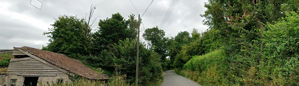
Curload Hill - Dug Out by Hand

This is the bottom of Curload Hill, before it was surfaced with macadam. You can just see the ground on the left rising above the road.
Stoke, along with all other ecclesiastical parishes, was first made legally responsible for maintaining the roads in the parish by the Highways Act 1555, when Mary Tudor was on the throne. Every Easter week our village worthies had to elect two ‘honest persons’ as Surveyors of Highways. Those surveyors then had to designate four days of road work. They had the power and duty to call on every ploughland holder to provide a cart equipped for road repairs plus two able-bodied men, with an optional two extra men in lieu of the cart. All other householders, cottagers, and free labourers were required to supply themselves (or substitutes) as labourers for eight hours a day during the four days. They were also empowered to inflict penalties of 10 shillings per unprovided draught and 12 pence per labouring day missed. Every labourer had to furnish his own tools and materials for ‘cleansing, scouring, and repairing the ways’.
What would we be able to achieve in 2026 if we had a similar meeting next Easter Week? Would we have a band of willing volunteers? Or would it be a case of: ‘We pay our rates. It’s the Council’s job!’?
A subsequent Act of 1691 formalised the role of the Surveyor of Highways, who then had to: Three times annually inspect all roads, byways, watercourses and pavements. Make sworn presentations to the next Quarter Sessions on any “ruyne and decay.” And also compell adjacent landowners to clear obstructions and cleanse gutters and drains along the parish roads.
Nothing much changed until the Turnpikes emerged (yes we did have a short stretch in Stoke - more later) and County Councils took over highways in the 19th century. In the meantime, one of the village problems that the Parish tackled was how to get hay up to the village from the newly drained Curry Moor, Stanmoor and West Sedgemoor. For some reason Collickshire Lane was not seen to be worth improving, although it was, and still is, the obvious route from the village centre to the Tone, with no steep gradients. Maybe Stanmoor was too flooded to provide a year round route? Maybe the landowners would not permit a made up road? For whatever reason, what happened was a route up what is now Griggs Hill and down Curload Hill.
As you have walked, ridden or driven down Curload Hill, have you noticed the steep banks at either side of the road that rise up after you pass Woodhouse Farm on your right. The ground either side of the road drops steeply here to Curload, especially down the slope of Windmill Hill. In order that loose hay could be hauled up from Curry Moor, the Parish authorised the gradient to be ‘rationalised’. Teams of men with pick and shovel would have dug through the various strata (including the north curry sandstone) to provide a more even gradient for the hay carts. We have not been able to find the details in the parish records (a job for someone whose eyes can cope with microfiche for longer than five minutes!) but there are records in North Curry of the people who were paid to do the same job where White Street dives down to Helland.